This workpackage is concerned with improving our metrological characterisation of measurements of GAIA-CLIM target Essential Climate Variables (ECVs). To enable a comprehensive comparison between a satellite and non-satellite measurement requires a full metrological characterisation of at least one of the two measurements (reference-quality data). A full characterisation requires an unbroken chain of measurement processing to SI or accepted standards and a quantification of the uncertainty in each step. The workpackage shall:

  • Create, to the extent possible, fully traceable reference-quality measurements for a number of measurement techniques that are close to such maturity (Task 2.1).
  • Analyse existing comparisons and observations to provide more indicative uncertainties for observations from the remainder of the global observing system capabilities (Task 2.2).
  • Undertake metrological auditing and produce best practices documentation for improving instrument characterisation (Task 2.3).
Image

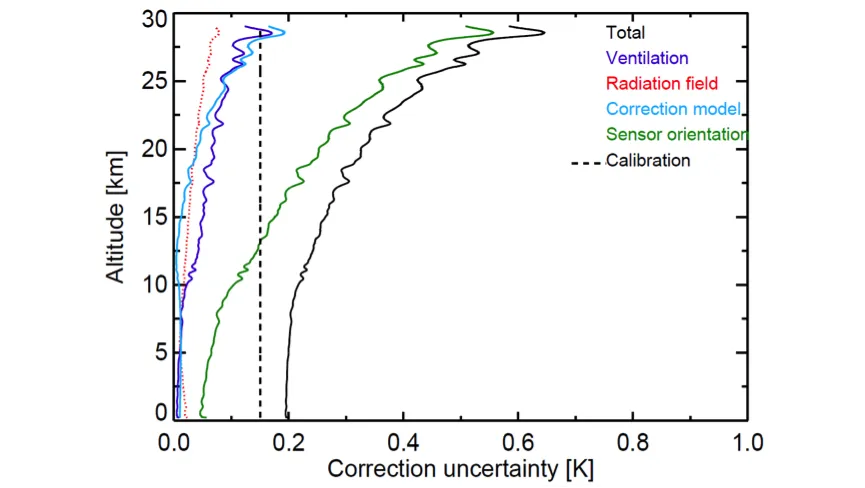
Figure: Example metrological characterisation of a radiosonde profile from Dirksen et al., 2014.

First traceability model diagrams can be found here.

Product Traceability and Uncertainty (PTU) documents can be found here.

G2.13 Missing microwave standards maintained by national/international measurement institutes

The traceability of ground-based microwave radiometer (MWR) estimates and their uncertainty requires the traceability of MWR calibration to SI standards. Currently, no SI standard is available for MWR at any national/international measurement institute. Thus, full SI-traceability of ECVs from MWR is currently not feasible. However, at least one national measurement institute is currently developing SI standards for MWR. It is expected that SI-traceable standards for MWR will be available in the next few years.

G2.12 Lack of rigorous pure rotational Raman temperature lidar error budget availability limits utility for applications such as satellite characterisation

Temperature lidars provide important information for trend detection in the middle atmosphere (connected to trends in the ozone layer). These are measured using lidar systems that often also measure the ozone layer. The lidar technique to measure temperature is sensitive to the presence of aerosol, which is an important contribution to the error budget. In addition, lidar techniques exist to measure temperature profiles in the troposphere using the pure-rotational Raman (PRR) technique that can be used in the presence of aerosol.

G2.11 Lack of rigorous tropospheric ozone lidar error budget availability

Tropospheric ozone has an impact on air quality and acts as a greenhouse gas and therefore plays a role in public and environmental health, as well as climate change, linking the two subjects. In order to establish tropospheric ozone trends, more high-quality and high-frequency observations are needed (see G.2.10) and a rigorous error budget is required. Measurements of tropospheric ozone by means of the Differential Absorption Lidar (DIAL) technique are close to reference quality and may meet this need if development of traceable products can be realised.

G2.10 Tropospheric ozone profile data from non - satellite measurement sources is limited and improved capability is needed to characterise new satellite missions

Tropospheric ozone has an impact on air quality and acts as a greenhouse gas and therefore plays a role in public and environmental health, as well as climate change, linking the two subjects. Establishing processes and trends in tropospheric ozone, in particular in the free troposphere, above the mixed layer and below the stratosphere, is difficult due to a lack of data. Also, ozone soundings using balloon borne samplers are too scarce to capture the relatively high spatial and temporal variability in the troposphere.

G2.08 Need for a metrologically rigorous approach to long - term water vapour measurements from Raman lidars in the troposphere and UT/LS

One of the paramount needs for developing long-term ECV datasets for atmospheric monitoring is to calibrate measurements using SI traceable standards. For water vapour measured with the Raman lidar technique, a solution is represented by the calibration of water vapour profiles using reference calibration lamps, which are traceable to NMIs standards.

G2.07 Lack of uptake of lidar measurements in data assimilation

Aerosol lidar data can potentially be used to constrain uncertain model processes in global aerosol-climate models. Satellite-borne lidar data can be effectively assimilated to improve model skill but, currently, aerosol lidar data assimilation experiments are mainly limited to the assimilation of attenuated backscatter, which is a non-quantitative optical property of aerosol. There is much additional valuable data that could be utilised to improve data assimilation.

G2.06 Current poor spatial coverage of high-quality multi-wavelength lidar systems capable of characterising aerosols

Raman lidars or multi-wavelength Raman lidars are undoubtedly an integral component of an aerosol global measurement infrastructure as they can provide quantitative range-resolved aerosol optical and microphysical properties. It is very important to carefully assess the value of the retrieval of advanced lidar systems and to study if the global coverage of the existing networks is sufficient to carry out adequate satellite-retrieval characterisation.