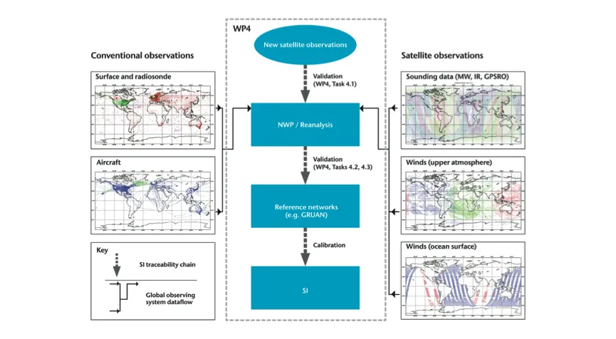
This workpackage is concerned with the potential utility of data-assimilation systems used in Numerical Weather Prediction (NWP) and reanalyses to use reference-quality data to make geographically broader implications about satellite-observational performance. The workpackage shall:

  • Assess the performance of a number of new satellite systems using reference-quality data and data assimilation (Task 4.1).
  • Develop infrastructure for near-real-time acquisition of reference-quality data (Task 4.2).
  • Develop software systems to enable monitoring of reference-quality data streams using global data assimilation systems (Task 4.3).
  • Develop a more general approach to use of reference-quality data in data assimilation, including for oceanic and terrestrial Essential Climate Variables (ECVs) (Task 4.4).
Image

Figure: Conceptual illustration of the potential route by which data assimilation can be used together with reference-quality measurements for assessments of satellite-data quality.

Validation practices for satellite-based Earth observation data across communities

Assessing the inherent uncertainties in satellite-data products is a challenging task. Different technical approaches have been developed in the Earth Observation (EO) communities to address the validation problem, which results in a large variety of methods as well as terminology. This paper reviews state-of-the-art methods of satellite validation and documents their similarities and differences. It originates from an activity of the International Space Science Institute (ISSI) for "EO validation across scales” with the involvement of GAIA-CLIM WP3 and WP4 leads.

G4.12 Lack of reference-quality data for temperature in the upper stratosphere and mesosphere

The GCOS Reference Upper Air Network (GRUAN) provides reference in-situ data for temperature and humidity with traceable estimates of uncertainty. This network can be used to validate NWP short-range forecasts for temperature and humidity to reference standards (see gap G4.01). The NWP temperature and humidity forecasts can then be used to perform satellite Cal/Val of new instruments, with improved knowledge of the associated uncertainties. However, there are very few GRUAN data above 40 hPa and none above 5hPa.

G4.10 Incomplete estimates of uncertainties in land surface infrared emissivity atlases

Land surface emissivity atlases in the infrared region (3-17 μm) are required for the validation of infrared satellite sounding measurements over land. Work is underway, outside of the GAIA-CLIM project, to develop dynamic atlases of spectral emissivity in this part of the spectrum, based on measurements from polar-orbiting hyper-spectral infrared observations and using a rapidly updating Kalman Filter. However, these new dynamic atlases need to be validated to ensure the estimates have robust uncertainties associated with them.

G4.09 Imperfect knowledge of estimates of uncertainties in land surface microwave radiative transfer

There is a lack of traceable uncertainties associated with the contribution of land surface microwave radiative transfer to Top of the Atmosphere (TOA) brightness temperatures for microwave imaging and sounding instruments. The land surface emission exhibits significant spatial and temporal variability, particularly in snow- and ice-covered regions.

G4.08 Estimates of uncertainties in ocean surface microwave radiative transfer

Several passive microwave missions (operating in the 1-200 GHz range) make measurements in spectral regions where the atmosphere is sufficiently transmissive so that the surface contributes significantly to measured radiances. The calibration/validation of microwave satellite data to reference standards is hampered, for some instruments and channels, by a lack of traceable estimates of the uncertainties in the modelled ocean surface contribution.

G4.01 Lack of traceable uncertainty estimates for NWP and reanalysis fields & equivalent TOA radiances – relating to temperature and humidity

Numerical Weather Prediction (NWP) models are already routinely used in the validation and characterisation of Earth Observation (EO) data. However, a lack of robust uncertainties associated with NWP model fields and related top-of-atmosphere (TOA) radiances prevent the use of these data for a complete and comprehensive validation of satellite EO data, including an assessment of absolute radiometric errors in new satellite instruments.