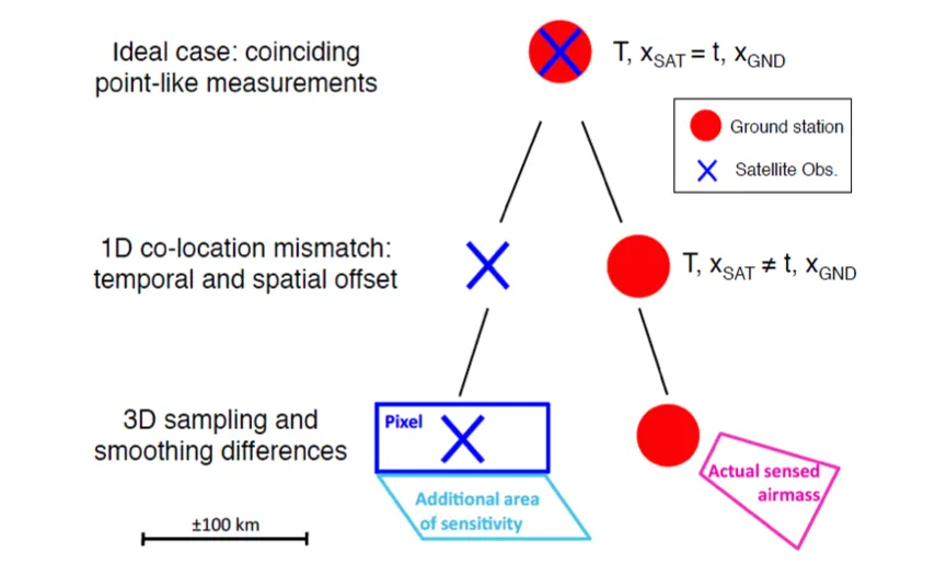
This workpackage is concerned with improving our quantification of irreducible uncertainties that arise from inevitable non-coincidence of satellite and non-satellite measurements. The measurements may occur at slightly different times or locations or measure different volumes. Because the atmosphere is a dynamic fluid system any mismatch will lead to a difference that arises from changes in the atmospheric state. These differences must be accounted for in any meaningful comparison between the satellite and non-satellite measurements if reliable inferences are to be made. The workpackage shall:

  • Characterise the uncertainties arising for single instruments (Task 3.1).
  • Characterise the uncertainties arising for more spatially comprehensive network comparisons (Task 3.2).
  • Develop software tools to enable the use in the forthcoming “Virtual Observatory” (WP5, Task 3.3).
Image

Figure: Conceptual visualisation of the metrology of a satellite-ground measurement comparison Verhoelst et al., 2015.

Validation practices for satellite-based Earth observation data across communities

Assessing the inherent uncertainties in satellite-data products is a challenging task. Different technical approaches have been developed in the Earth Observation (EO) communities to address the validation problem, which results in a large variety of methods as well as terminology. This paper reviews state-of-the-art methods of satellite validation and documents their similarities and differences. It originates from an activity of the International Space Science Institute (ISSI) for "EO validation across scales” with the involvement of GAIA-CLIM WP3 and WP4 leads.

G3.06 Missing comparison (validation) uncertainty budget decomposition including uncertainty due to sampling and smoothing differences

A data validation study is meant to check the consistency of a given dataset with respect to a reference dataset within their reported uncertainties. As such, the uncertainty budget of the data comparison is crucial. Besides the measurement uncertainties on both data sets, the discrepancy between the two datasets will be increased by uncertainties associated with data harmonization manipulations (e.g. unit conversions requiring auxiliary data, interpolations for altitude regridding) and with co-location mismatch, i.e.

G3.05 Representativeness uncertainty assessment missing for higher-level data based on averaging of individual measurements

Level-3 data are, by definition, constructed by averaging asynoptic level-2 data over certain space-time intervals, so as to arrive at a (regularly) gridded data product. However, the (global) sampling pattern of the sounder(s) that produced the original level-2 data is never perfectly uniform, nor are revisit times short enough to guarantee dense and homogeneous temporal sampling of e.g. a monthly mean at high horizontal resolution.

G3.02 Missing standards for, and evaluation of, co-location criteria

The impact of a particular choice of co-location criterion is only rarely studied in the scientific literature reporting on satellite validation results. However, without some quantification of the impact of the co-location criterion that was adopted, it is virtually impossible to assess the contribution of natural variability to the total error budget of the data comparisons. As such, this gap impacts significantly the potential interpretation of the data comparison result in terms of data quality.

G3.01 Incomplete knowledge of spatiotemporal atmospheric variability at the scale of the measurements and of their co-location

The atmospheric concentration of nearly all ECVs varies in space and time at the scale of the individual measurements, and at the scale of their co-location in the context of data comparisons (e.g., for the purpose of satellite validation, data merging, and data assimilation). However, the amplitude and patterns of these variations are often unknown on such small scales. Consequently, it is impossible to quantify the uncertainties that result from sampling and smoothing properties of the measurements of the variable, structured atmospheric field.

Paper published

An initial paper on “Metrology of ground-based satellite validation: co-location mismatch and smoothing issues of total ozone comparisons” is explaining underlying principles of GAIA-CLIM research and demonstrating their application to total ozone column comparisons. The paper has now been published in AMT.